John-Suwan Viewpoint: Koh Tao’s Most Beautiful Panorama
Heads up: This article may contain affiliate links. If you book through them, I may earn a small commission at no extra cost to you. Prices listed are approximate and may vary by season. Check the links for current rates and availability.
Wondering whether the John-Suwan Viewpoint hike in Koh Tao is worth it?
Short answer: absolutely — if you’re prepared for a short but steep climb.
With panoramic views over Shark Bay and Chalok Baan Kao Bay, this is easily one of the most rewarding viewpoints on the island. But despite what Google Maps might suggest, getting there (and getting to the actual viewpoint) is a little more adventurous than expected.
Here’s exactly what to know before hiking to John-Suwan Viewpoint — from parking and entrance fees to trail conditions, difficulty, and what the view is really like at the top.
John-Suwan Viewpoint offers a great vantage point over the island, plus a short but rewarding hike!
Getting There (Don’t Trust Google Maps Too Much)
On Google Maps, it looks like you can drive right up to the trailhead — but you can’t.
Instead, you’ll need to stop at Freedom Beach Resort, where you can park your scooter or get dropped off by taxi.
There’s a 50 THB entrance fee, which gives you access to both the viewpoint trail and Freedom Beach — a super nice little swimming spot — giving you a good bang for your buck.

The Hike: Short, Fun… and a Challenge
Key Points: John-Suwan Viewpoint Trail
⌚ Time estimate: ~30 minutes total, depending on how often you stop for photos (you will 😄).
🕘 Best times to go: Try going early morning (I read that if you go before 8 AM, they don’t charge anything) or late afternoon / just before sunset
☀️ Conditions: The trails are in good condition; they are just challenging. There are ropes set up to help climbers. There is almost no shade on this trail, so it can be extremely hot around midday. Avoid this trail after the rain.
At first you think “this is going to be easy!” and then… you get passed this part into the real fun part! :)
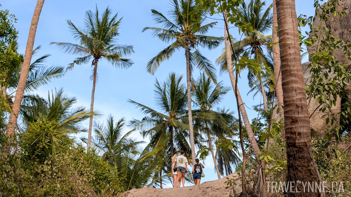
The hike starts off easy, with a concrete path (pictured above with the puppy) that gradually leads you uphill.
As you continue, you’ll start to see dirt trails, glimpses of the ocean through palms, and picture-perfect spots on rocky cliffs. Some people stop here, but it’s definitely not the best part!
But once you turn right and begin the main ascent, things get more intense.
For about 15 minutes, you’ll be:
climbing over large rocks
navigating steep, uneven steps
using ropes set up to help you along the way
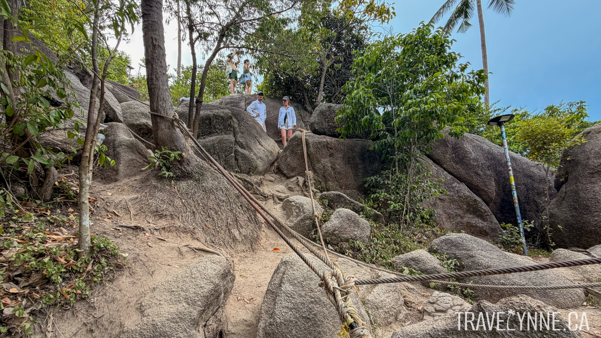
Rope systems have been set up throughout the last part of the trail to help climbers hoist and stabilize as they make their way up and down.
It’s actually really well done — and a lot of fun — but it’s definitely not a casual stroll.
👉 If you’re reasonably fit and mobile, you’ll be fine. Just be prepared to use your hands, take some huge steps, and take it slow.

It doesn’t really look like a trail, but the rocks are the trail in this hike :)
The Final Stretch
When you reach the top of the hill, it might feel like that’s it.
But it’s not.
To get to the actual viewpoint, you’ll need to:
slip between two large rocks (see photo below)
climb up a few more rocks
watch your step, as the clearing is also on rocks with no ledges
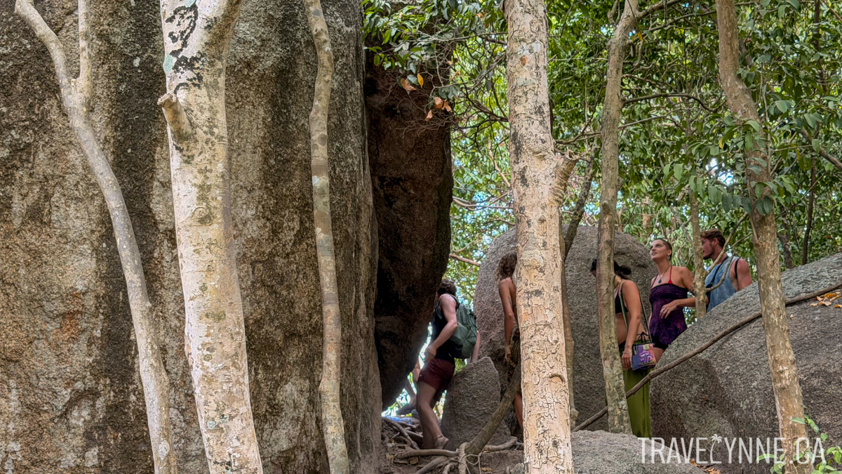
To access the viewpoint, you need to slide through these rocks at the top of the hill you’ve climbed — then you’re just about there!
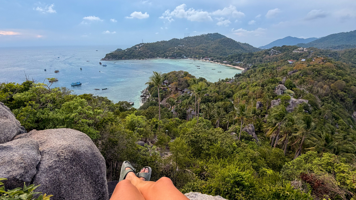
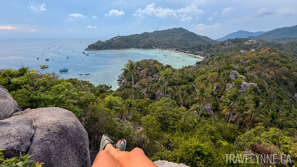
The View: One of the Best in Koh Tao
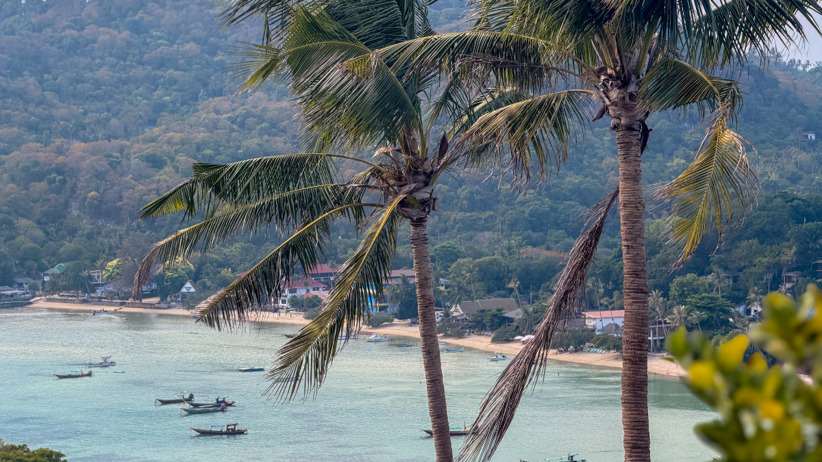
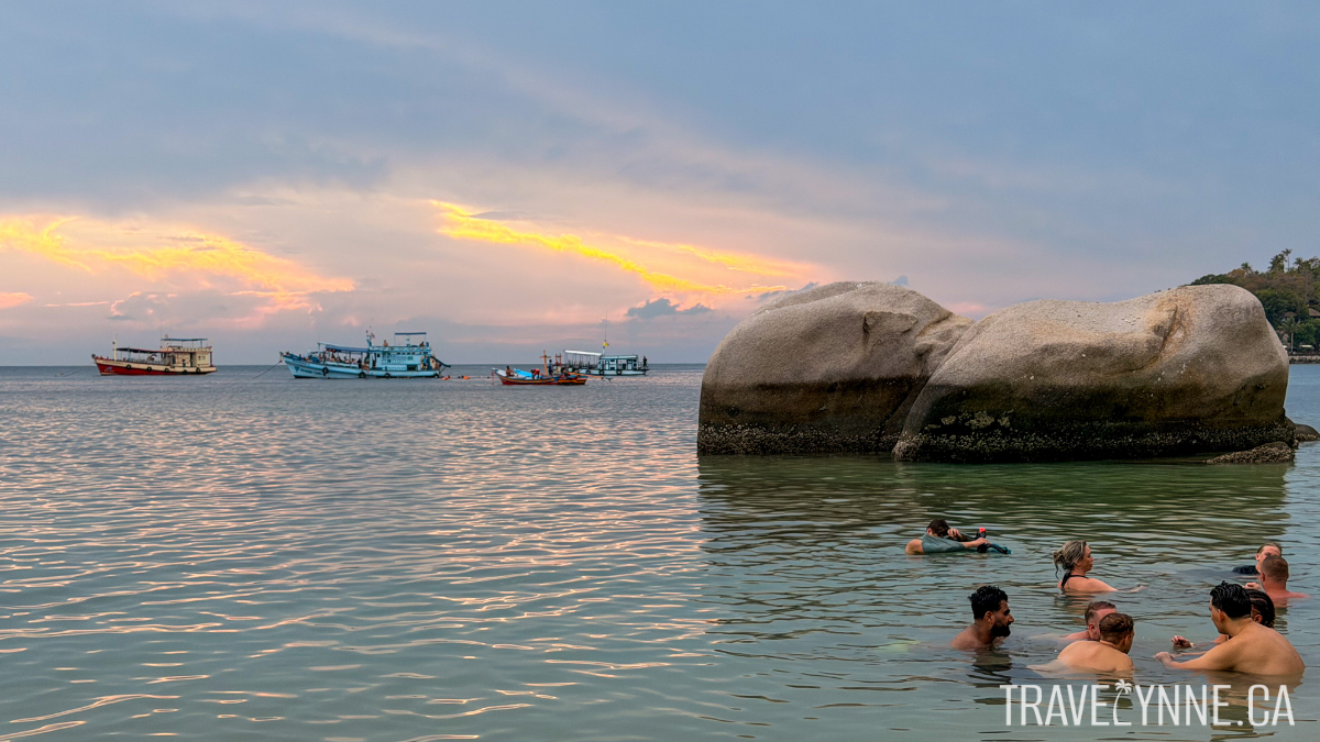
At the top, you’re standing on a narrow peninsula with two bays on either side — Chalok Baan Kao Bay and Shark Bay.
You’ll see shades of bright turquoise water, snorkeling boats and snorkellers scattered across both bays, lush green hills, and coastline.

The view on the way up and down are almost as rewarding as the views from the very top!

The descent is always kind of misleading, isn’t it? Harder than it looks!
REMINDER: The summit is small and uneven, and some rocks aren’t fully stable. If you’re taking photos — especially facing away from the drop — be very mindful of your footing and surroundings.

The Descent: What Goes Up Must Come Down
There is no loop here — you’ll go back down the same way you came up. Be very mindful on the way down, as there is a lot of loose sand and unstable footing. You can take your time — there’s no rush in island life anyway!

The way down can be slippery — be careful! And learn from my mistake… wear closed toe shoes ;)
What to Bring
A few things will make your experience much better:
Closed-toe shoes — I highly recommend you don’t do this in slides, as they’ll just keep slipping off on the fine sand! There are also many rocks and other risks, so it would be best to wear running shoes with decent grip.
Water — It’s not a long hike, but it is very sweaty! Take care by drinking and bringing enough water.
Sun protection — hat and sunscreen (there’s almost no shade here!)
Confidence on uneven terrain — it’s short, but requires focus… you’ve got this!
🌿 Make It a Half-Day Trip
Since you’re already in the area, it’s worth combining this hike with nearby spots and making it a half-day (or full-day, if you really wanna chill!) in the south of the island.
The bay at Freedom Beach is ideal for swimming and chilling
Here’s what I would combine with the viewpoint hike:
Freedom Beach — right below the viewpoint, perfect for a swim after
Taa Toh Lagoon — a quieter alternative spot, also included in your entry fee
Lunch in town — the town road nearby is home to several highly rated restaurants you can pop into after enjoying the beaches and viewpoint, especially if you’re looking for better quality and prices than what you’ll find at the parking lot or beach. I’ll give some suggestions here! ⤵️
Restaurants Nearby
These restaurants or stalls are within ~5 minutes’ drive of the John-Suwan Viewpoint parking lot:
Sandwich Lady: For something simple and inexpensive but delicious, grab a sandwich (or Thai dish, salad or brekky) from this stall, starting at 70 THB.
Matchima: For Thai food with a sit-down restaurant, try this spot! Customers rave about the generous portions and great flavors starting at 100 THB.
Croissant & Ko: If you’re after high-quality bread, pastries or pizza, this is your spot. Sandwiches starting from 100 THB.
Wizards of Koh Tao: This is the place for all kinds of interesting drinks, from coffee to kombucha to cocktails, plus a chill outdoor hangout area with games.
The town road just 5 minutes from the viewpoint parking lot has loads of great options for food!
Final Thoughts
John-Suwan Viewpoint may be kind of challenging to reach, but if you’re able, it’s also a fun adventure with rewarding views.
Between the climb, the rocky final stretch, and the sweeping views over Koh Tao’s southern bays, it’s one of those experiences that makes you really appreciate the island.
Go early (or before sunset), bring proper shoes and plenty of water, and take your time. Combine the visit with nearby beaches and restaurants for a beautiful day! The views here are so worth soaking in.

With loads of trees, Freedom Beach offers so much shade and calmer waters — it’s very relaxed and
Was this helpful? Have more questions? You can reach me by Instagram DM or sending me an e-mail!

Planning a complicated Asia itinerary? I help independent travelers design custom trips that balance logistics, local culture, and meaningful experiences. Click here to learn more about my travel planning services.
READ NEXT: